Tuesday, 21 February 2023
eggbuckland ,Bocheland is of Saxon origin and means "Royal land held by charter".
Tuesday, 17 May 2022
Tuesday, 26 April 2022
St Winnow cornwall
This article needs additional citations for verification. Please help improve this article by adding citations to reliable sources. Unsourced material may be challenged and removed. Find sources: "St Winnow" – news · newspapers · books · scholar · JSTOR (January 2010) (Learn how and when to remove this template message) |
St Winnow
| |
|---|---|
 St Winnow Parish Church | |
Location within Cornwall | |
| Population | 312 (United Kingdom Census 2011 including Braddock) |
| OS grid reference |  SX1157 SX1157 |
| Civil parish |
|
| Unitary authority | |
| Ceremonial county | |
| Region | |
| Country | England |
| Sovereign state | United Kingdom |
| Post town | LOSTWITHIEL |
| Postcode district | PL22 |
| Dialling code | 01208 |
| Police | Devon and Cornwall |
| Fire | Cornwall |
| Ambulance | South Western |
| UK Parliament | |
 50.383°N 4.652°WCoordinates: 50.383°N 4.652°WCoordinates:  50.383°N 4.652°W 50.383°N 4.652°W | |

St Winnow (Cornish: Sen Gwynnek[2]) is a civil parish in Cornwall, England, United Kingdom. Its name may be connected with either that of Saint Winnoc or Saint Winwaloe. It has a population of 304,[3] which had increased to 328 at the 2011 census.[4] The church town is on the east bank of the River Fowey south of Lostwithiel. Part of the village of Lerryn lies within the parish as does the Chapel of St Nectan. The Redlake Meadows & Hoggs Moor, a Site of Special Scientific Interest is also in the parish.
Contents
History and antiquities[edit]
St Winnow was recorded in the Domesday Book of 1086 as San Winnuc. In 1644-45, some ninety people from the parish died of the plague: only four were soldiers but a campaign of the Civil War was going on at the time.
Andrew Langdon (1996) records three stone crosses in the parish. A cross found at Higher Coombe in 1903 was afterwards erected at St Nectan's chapel. A cross from Lanlivery was made into the upper section of "The Monument" on Druids Hill. It was brought from Lanlivery in 1846; this monument commemorates the loss of life in the Battle of Braddock Down in 1643. A third cross called Waterlake Cross stands in a private garden near Respryn.[5] The third cross had already been recorded by Arthur G. Langdon in 1896; at Waterlake, a hamlet near Bodmin Road station, there is a Cornish cross.[6]
Churches and chapels[edit]
Parish church[edit]
This is of Norman foundation but the present building is almost entirely of the 15th century. The rood screen survives and there is some interesting stained glass.
The church is at the riverside, next to a quay at the limit of navigation of the River Fowey. It is probably on the site of the 7th century oratory of St Winnoc. A stone church was built in the 12th century, probably cruciform in plan, and there are traces of the Norman stonework on the north side. The transept arch was reconstructed in the 13th century. About 1465 the south wall was demolished and the south aisle, arcade and roofs built. The chancel was restored by J. H. Seddon in the 19th century, retaining the 16th century east window. The west tower is of standard Cornish Perpendicular style. There is stained glass of c. 1500 in the east windows of the chancel and S aisle. The 16th century rood screen, carved with leaves and flowers, was restored by Violet Pinwell in 1907 (by Edmund H. Sedding according to Pevsner). The loft, rood and some of the south aisle screen were newly made in the restoration. The granite font, carved with angels bearing shields, is 14th century. The pulpit is of c.1600 and richly carved. There are also carved bench ends of various dates from 1485 to 1630. The monuments include one in slate to William Sawle, d. 1651.
A burial plot with Celtic-style headstones for the Vivian family occupies the north-west corner of the churchyard.
Chapels[edit]
The chapel of St Nectan is of the 13th and 15th centuries but the north aisle was added in 1825. The tower has lost its upper stages due to the Civil War (1644).[7] The medieval parish was larger and included Boconnoc and St Bradoc: the chapels of St Nectan and St Martin's at Respryn were quasi-parochial.[8] The 14th century font from Respryn was reused at Herodsfoot.
Education[edit]
There is a primary school in St Winnow, St Winnow C E School. The majority of children aged between 11 and 16 attend Fowey River Academy.
Transport[edit]
Due to delays in securing the site for Bodmin Road, the Cornwall Railway provided a temporary station at Respryn for the opening of the line on 4 May 1859 until the permanent station was ready on 27 June 1859.
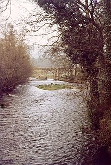
Respryn Bridge (illustrated above right) is a fine medieval stone bridge over the River Fowey. The present bridge was built in the 15th century to replace one which had already existed in 1300.[9]
Ethy[edit]
References[edit]
- ^ This was the site of a major battle between Cavaliers and Roundheads during the Civil War
- ^ "Cornish Language Partnership : Place names in the SWF". Magakernow.org.uk. Retrieved 20 October 2016.
- ^ "Check Browser Settings". Neighbourhood.statistics.gov.uk. Archived from the original on 23 December 2015. Retrieved 20 October 2016.
- ^ "Parish population 2011". Genuki.org.uk. Retrieved 14 February 2015.
- ^ Langdon, A. G. (2005) Stone Crosses in East Cornwall; 2nd ed. Federation of Old Cornwall Societies; pp. 70-72
- ^ Langdon, A. G. (1896) Old Cornish Crosses. Truro: Joseph Pollard; pp. 68-69
- ^ Pevsner (1970) Cornwall, 2nd ed. Penguin Books, pp. 196, 204-05
- ^ Cornish Church Guide (1925) Truro: Blackford; pp. 220-221
- ^ Beacham, Peter & Pevsner, Nikolaus (2014). Cornwall. New Haven: Yale University Press. ISBN 978-0-300-12668-6; p. 274
Further reading[edit]
- Brown, H. Miles. (1994) The Book of St Winnow. Liskeard: Artworks.
External links[edit]
 Media related to St Winnow at Wikimedia Commons
- GENUKI website; St Winnow
- Cornwall Record Office Online Catalogue for St Winnow
Saturday, 28 April 2018
Lower Hooksbury Wood
Sunday, 7 January 2018
SECRETS OF THE HIDDEN SOURCE IN SEA Parish: Chagford
|
Ordnance Survey Explorer Map OL28
Another of Devon's Stannary towns. Today it is a delightful base from which to explore the fringes of the moor. Castle Drogo near here is sometimes called the last castle built in England, and its position overlooking the steep wooded slopes of the River Teign is very suggestive of a medieval defensive site. This National Trust property only dates from the last century but it is impressive w and so too is the much smaller burial chamber at Spinster's Rock, a couple ol miles away, which is more than 3000 years older than Castle Drogo. This is an area where careful study of the Ordnance Survey map will reveal much ol interest, including Chagford Bridge, Gidleigh Castle and the standing stones and stone rows on Chagford Common.
Grid Reference: SX716861. Good public access; the well is l»v the roadside.

The name supports the appeal ance of this well as the massive moss-covered granite slabs loo) a if they have stood here for cvei However this may not be for m 11 < I i longer as a recent collision wilb it vehicle has shifted the stones lit the extent that they now lonl In danger of collapse, and the* '•pilii| which they protect is t hoi*ml with mud and debris. The slle I* next to Middlecott whicli was rt Domesday settlement and clime by are two ancient stone < nm*nH known as Middlecott Cross anti Week Down Cross. These alt* early Christian monuments dalliii from 7th-9th centuries ami suggest that a route at mss I hit moor once ran through hen
 |
Friday, 10 June 2016
DUNSTER
there, though the historian quaintly adds that the plague was at the same time “ hot round Dunster.” Behind what is still called the Prince’s bedchamber is a secret chamber or hiding-place of small dimensions. Later, the Castle was besieged by Colonel Blake, the Parliamentarian Governor of Taunton, who, after a close siege of 160 days, forced Colonel Francis Wyndham to surrender, but with the honours of war. In 1648 the Castle was the prison of William Prynne, who had been sent there by Oliver Cromwell. During his imprisonment he employed his time in examining and scheduling the many documents connected with the history of the Castle. Perhaps the most interesting of these is a small slip of parchment bearing the original receipt of the Lady Joan de Mohun to the Lady Elizabeth Luttrell for 500 marks, the purchase money paid by the latter lady in 1376 for the right of succession to the Great Barony of Dunster.The Tor on which the Castle stands was the site of the Norman Keep, but all traces have disappeared, the Keep having been destroyed, by order of Parliament, in 1650. The Tor is covered with fine trees and every variety of flowering shrub, among which, growing in the open air on a wall in front of the Castle, is a lemon tree of remarkable luxuriance and beauty, bearing fine fruit. On it may be noticed the unusual sight of bud, blossom and fruit at the same time.
The view from the neighbourhood of the Castle is varied and imposing, including the extensive Deer Park, several miles in circumference, and, nearer, the verdant lawns, 300 acres in extent.On the heights of the Deer Park, on Gallox Hill, are two ancient camps. The prominences silhouetted against the sky mark the site of a roughly rectangular earthwork, known as Bat’s Castle, and often called the “ Roman camp.” It is enclosed by a double vallum of stones and a fosse, except on the southern side, where the steep declivity renders such protection unnecessary. Not far away, to the north-west, on the same hill, is a well-marked circular camp.The High Street.Dunster High Street, once called “ Chepyng-strete, ” is a broad and dignified thoroughfare, flanked by many charming Tudor houses with carved oak doorways and heavy window-frames, and quaint little old-fashioned shops. High above the Castle mounts guard over the lower end, and at the otherMinehead (c)
Sunday, 25 October 2015
Cado, King of DumnoniaCado
(c.AD 482-537)
(Welsh: Cadwy; Latin: Cadorius; English: Cador)
(Welsh: Cadwy; Latin: Cadorius; English: Cador)
Saturday, 26 September 2015
Dumnonia
EBK: King Gerren Llyngesoc of Dumnonia
Gerren Llyngesoc, King of DumnoniaEBK: King Gerren Llyngesoc of Dumnonia
(Born c.AD 448)
(Welsh: Gereint; Latin: Gerontius; English: Gereint)
The eldest son of King Erbin of Dumnonia. Arthurian tradition would have us believe that, after the death of his his wife, “Sir Gereint” spent much time at King Arthur‘s Court, looking for action and adventure. It was supposedly during this period that he encountered the Sparrow Hawk Knight and came to marry Lady Enid of Caer-Teim (Cardiff), a story told in the ancient tales of “Erec (alias Gereint) & Enid” and “Geraint mab Erbin”. He inherited the Dumnonian throne in c.497 (or 480) and is recorded as one of the great “Fleet Owners” of post-Roman Britain His castle was once called Caer-Gurrel or Fort of the Ship. He died fighting the Saxons with the High-King Arthur at the Battle of Llongborth (Portsmouth, Somerset) around 480/510. This recorded in a long Welsh poem called the “Elegy for Gereint”. He was succeeded by his son, Cado.


