As with most hydronymy in England (such as the Ouse and Avon), the name is likely to be of Celtic origin.[2]
The same name appears in the 'Neen', the former name of the river Rea in Shropshire, which is retained in the hamlet of Neen Savage. A.D. Mills however considers the name 'obscure' and suggests that it may be pre-Celtic.[3]
The pronunciation of the river's name varies by locality. In Northamptonshire, it is usually /ˈnɛn/, and around Peterborough, it is usually /ˈniːn/. The spelling was "Nenn", as seen in Cole-Roper's 1810 engraving, or "Nyn", the Ordnance Survey of 1885 is 'Nene'[4], and the point at which the pronunciation changes has been moving further inland for many years; the current edition of the Imray "Map Of The River Nene" suggests that it is now Thrapston.[5]
The river's most westerly source can be found near the village of Badby, near Daventry. On the eastern slope of Arbury Hill, and in pools between Arbury Hill and Sharmans Hill, there are three tributaries that converge at Dodford mill to form the upper reaches of the Daventry Nene. The two northern streams flow through the villages of Badby and Newnham to the convergence, whilst the southerly stream runs through Fawsley Park and through the village of Everdon before the convergence. From Dodford, the river passes through the village of Weedon where it flows under the main west coast railway line, the Grand Union Canal, and Watling Street. A little west of Weedon, the river converges with its tributary source from Yelvertoft from the north. This tributary, the Yelvertoft Nene, is formed from a great many streams. The river now flows towards Northampton, passing through Flore and Nether Heyford, where it is joined by small streams on either bank. A little past Bugbrooke Mill, the Nene passes under the M1 motorway and falls over a weir towards Kislingbury.
Another tributary merges from the south at Kislingbury. The Nene's course is closely followed by the Grand Union Canal’s Northampton arm at Upton Mill.
Passing Irthlingborough on its north-western bank, the Nene now flows past Nene Park, the former ground of Rushden and Diamonds F.C.. Further on, the river is crossed by the disused track bed of the Northampton and Peterborough Railway which was constructed in 1845. The river is now characterised by large curving meanders as it passes the villages of Little Addington, Great Addington and Denford.
 Having passed among the gentle hills of Northamptonshire the river enters the rural part of the City of Peterborough, passing the Nene Valley Railway and through the Nene Valley Country Park. 1⁄2 mile (800 m) upstream of the city centre is Woodston Wharf—the site of the old sea lock—originally the extent of the tidal River Nene until the Dog in a Doublet lock at Whittlesey was opened in 1937. To the east of Peterborough city centre a branch of the river passes under the former Great Eastern Railway, now connected to the main East Coast main line and running through to Cambridge via Whittlesey and Ely. The branch terminates, for navigation, at Stanground Lock, a connection to the Middle Levels, the drainage system of the Fens through which access is possible to the River Great Ouse. Below Peterborough, the river forms the border between Cambridgeshire and Norfolk for about 3.7 miles (6.0 km).
Continuing downstream leads to the impressive 'Embankment' area and after the cathedral city itself, passing through Whittlesey the landscape changes to the Nene Washes in The Fens and their vast horizons. Beyond Flag Fen the river flows through the port of Wisbech, then Sutton Bridge in Lincolnshire, and it finally enters The Wash between two towers known as "the lighthouses".
The Nene links the Grand Union Canal to the River Great Ouse, via the Middle Level Navigations. Much of its route has been upgraded to a wide canal with locks at regular intervals. Some sections where artificial cuts run adjacent to the course of the river are known as the "Nene Navigation".
The Nene is navigable from just above its junction with the Northampton Arm of the Grand Union Canal to the sea. Most leisure use is between Northampton and Peterborough, where it makes a junction with the Middle Level Navigations at Stanground Sluice, which give access to the Bedfordshire River Ouse. There is no longer any significant commercial traffic.[17]
A failure to find anyone prepared to work on the Western Division from Thrapston to Northampton resulted in a third Act being obtained in 1756, which allowed the Commissioners to borrow money to finance the work. Lenders would become Proprietors of the Navigation, and the work was to begin at Thrapston and extend the navigable section towards Northampton. It took the Commissioners two years to agree who should carry out the work, but on 22 June 1758, John Smith jnr from Attercliffe, Yorkshire was contracted to construct 20 pound locks, 20 horse haling bridges and various other works at a cost of £14,070. The river opened to navigation in stages over the next three years, with a great celebration being held at Northampton on 7 August 1761 when the work was completed.[19]
The proprietors had the right to use tolls as they saw fit, and the Commissioners found that they had no powers to ensure the navigation was maintained in good order. They obtained another Act of Parliament in 1794, which aimed to rectify the situation, but it was not until 1801 that Thomas Wright replied to their requests, and some repairs were made. There was little traffic and income from tolls was low, at just £488 per year between 1801 and 1804. The Commissioners were also keen to see a link constructed from Northampton to the Grand Junction Canal, but the canal company argued that there was an insufficient supply of water. It was agreed that a link would be built in two halves, but that there would be 1 mile (1.6 km) of railway in the middle. When built, the canal company constructed the entire link as a railway, which opened in 1805. In a bid to get a navigable link, the Commissioners opposed the bill to build a link between the Grand Junction Canal and the Old Union Canal, but relented when they had a firm agreement that a navigable link to Northampton would be built. The link cost £35,000, was supervised by Benjamin Bevan, and was built between 1812 and 1815. It was nearly 5 miles (8.0 km) long, and dropped 107 feet (33 m) through 17 locks.[20]
Tolls rose to a little over £1,000 per year, but the Commissioners decided that the canal boats damaged the locks, and all traffic had to be transferred to river barges. This order was withdrawn in 1827, but the condition of the river gradually deteriorated, and the arrival of the Blisworth to Peterborough Railway in 1845 further reduced profitability. Flooding was also a problem, but the Commissioners had no powers to act as Commissioners of Sewers, to address the problems of drainage. With serious flooding in December 1848, a public meeting was held, and a committee was elected to consider Nene drainage. The main problem was a restriction at Wisbech, and the engineer James Rendel estimated that £120,000 was required to reconstruct the river below Peterborough. The Nene Valley Drainage and Improvement Act was obtained in 1852, to allow this work to be completed.[2
The same name appears in the 'Neen', the former name of the river Rea in Shropshire, which is retained in the hamlet of Neen Savage. A.D. Mills however considers the name 'obscure' and suggests that it may be pre-Celtic.[3]
The pronunciation of the river's name varies by locality. In Northamptonshire, it is usually /ˈnɛn/, and around Peterborough, it is usually /ˈniːn/. The spelling was "Nenn", as seen in Cole-Roper's 1810 engraving, or "Nyn", the Ordnance Survey of 1885 is 'Nene'[4], and the point at which the pronunciation changes has been moving further inland for many years; the current edition of the Imray "Map Of The River Nene" suggests that it is now Thrapston.[5]
Course[edit]
The River Nene is the tenth-longest river in the United Kingdom. From its source at Arbury Hill to Northampton, the river falls a total of 300 feet (91 m) in 17 miles (27 km).[1] For the remainder of its course, the Nene falls less than 200 feet (61 m).[6] It has a catchment area of 631 square miles (1,630 km2) and a mean flow of 328 cubic feet per second (9.3 m3/s).[7] The final 88 miles (142 km) from Northampton to the Wash is navigable.[8]The river's most westerly source can be found near the village of Badby, near Daventry. On the eastern slope of Arbury Hill, and in pools between Arbury Hill and Sharmans Hill, there are three tributaries that converge at Dodford mill to form the upper reaches of the Daventry Nene. The two northern streams flow through the villages of Badby and Newnham to the convergence, whilst the southerly stream runs through Fawsley Park and through the village of Everdon before the convergence. From Dodford, the river passes through the village of Weedon where it flows under the main west coast railway line, the Grand Union Canal, and Watling Street. A little west of Weedon, the river converges with its tributary source from Yelvertoft from the north. This tributary, the Yelvertoft Nene, is formed from a great many streams. The river now flows towards Northampton, passing through Flore and Nether Heyford, where it is joined by small streams on either bank. A little past Bugbrooke Mill, the Nene passes under the M1 motorway and falls over a weir towards Kislingbury.
Another tributary merges from the south at Kislingbury. The Nene's course is closely followed by the Grand Union Canal’s Northampton arm at Upton Mill.

Northampton[edit]
At Upton Mill, another tributary, called Wootton Brook, joins the river from the south. The River Nene now approaches Northampton town from the west, passing between the suburbs of St. James (locally known as Jimmy's End), Cotton End and Far Cotton. The Nene’s third northern source, the Naseby Source or Brampton Nene, converges at the Carlsberg Brewery. This tributary flows through the north of Northampton where several streams join. Three of these streams supply water for reservoirs at Pitsford, Hollowell and Ravensthorpe, north of Northampton, before joining the Brampton Nene. At Cotton End, the Nene passes under South Bridge, then through Beckett's Park and past the site of the former Northampton Power Station in the Nunn Mills area of the town, on the south bank of the river opposite Midsummer Meadow on the north banks.[9] Northampton Sea Cadets is based in Nunn Mills, and uses the river for the training of boating skills. Following the training schemes of the Royal Yachting Association (RYA), British Rowing (BR), and the British Canoe Union (BCU).[10] A short way downstream, a weir can divert some of the Nene's flow to supply the Nene Whitewater Centre.

Nene Valley[edit]
From Northampton, the river flows along a broad valley, formed by the enormous amount of water released by the melting ice during the Ice Age,[11] towards the east coast. The Nene now meanders through this wide, flat valley with flood plains, lakes, pools and mature gravel pits on either bank, a byproduct of the large glacial deposits in the valley. At Great Billing is Billing Aquadrome, a popular caravan and camping park with leisure facilities and a funfair, which is based around the river and various mature gravel pits.[12] The park is popular with fishermen and water skiers alike. The river's landscape is now dominated by mature gravel pit lakes. Some gravel extraction still takes place along the valley's basin. At Cogenhoe (pronounced /ˈkʊknoʊ/ locally[13]) the river passes through a watermill. The mill is a red-brick building built in the late nineteenth century, with a slate roof, from which all the machinery has been removed. Adjacent is a Mill House, built of coursed limestone rubble, and dated 1725.[14] At Earls Barton the river again passes an area of mature gravel pit lakes, and lock gates numbers 9 and 10. Further on, the river passes through Doddington Lock No 11 and the nearby Hardwater Watermill. This watermill, mentioned in the Domesday Book, ground wheat into flour for almost 1000 years. Thomas Becket, Archbishop of Canterbury, used the mill as a hiding place after escaping from Northampton Castle in 1164 and fleeing down the Nene to be sheltered by the miller before fleeing to France. The watermill ceased grinding flour after the Second World War. The present buildings date from the late eighteenth and early nineteenth centuries, and have been converted into dwellings.[15]Wellingborough[edit]
The river's course turns to the north-east, passing the town of Wellingborough on its north bank and the village of Little Irchester to the south. At Wellingborough, the river passes through Victoria Mills. Founded in 1886 by the Whitworth family, they are still run by the firm today, producing fine flours for the bakery trade. In front of the mill, there remains a jetty from the days when the river was used for transportation of goods to and from the mills. A little further on, the river is joined from the north by the River Ise. On the opposite bank are the remains of the Roman town of Irchester. The river now passes under a viaduct that carries the Midland Main Line, which links London St. Pancras International to Sheffield Midland station in northern England via Luton, Bedford, Kettering, Leicester, Derby, Nottingham and Chesterfield.
Passing Irthlingborough on its north-western bank, the Nene now flows past Nene Park, the former ground of Rushden and Diamonds F.C.. Further on, the river is crossed by the disused track bed of the Northampton and Peterborough Railway which was constructed in 1845. The river is now characterised by large curving meanders as it passes the villages of Little Addington, Great Addington and Denford.
Thrapston[edit]
At Denford the river divides into two channels, one of which is used for navigation. The channels approach the town of Thrapston, passing under two adjacent viaducts. One carries the busy A14 trunk road; the other carries the disused railway track bed. Between the town of Thrapston and the village of Islip, the Nene is spanned by a low nine-arched bridge. Just north of Thrapston the river forms part of the 180 acres (73 ha) of Titchmarsh Nature Reserve.[16] The reserve, designated in 1989, consists of two lakes, a woodland, river banks and areas of grass and scrub in which some ponds have been dug. The reserve is operated by Northamptonshire County Council, with the approval of the Nature Conservancy Council. At Aldwincle another tributary, called Harpers Brook, joins the Nene from the north-west. Harpers Brook flows between gravel pit lagoons before converging with the river. The river flows south of Oundle passing Barnwell Country Park and Oundle Marina under a bridge of the A605 road. At grid reference TL116976, the Romans bridged the river with Ermine Street in the first century. Between Oundle marina and Peterborough the Nene falls towards Peterborough, navigation passing through 11 locks on the way.
Peterborough[edit]


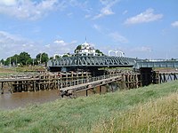
Crosskeys Bridge swing bridge on the River Nene before the mouth of The Wash, built in 1897, in the village of Sutton Bridge, south Lincolnshire
Continuing downstream leads to the impressive 'Embankment' area and after the cathedral city itself, passing through Whittlesey the landscape changes to the Nene Washes in The Fens and their vast horizons. Beyond Flag Fen the river flows through the port of Wisbech, then Sutton Bridge in Lincolnshire, and it finally enters The Wash between two towers known as "the lighthouses".
The Nene links the Grand Union Canal to the River Great Ouse, via the Middle Level Navigations. Much of its route has been upgraded to a wide canal with locks at regular intervals. Some sections where artificial cuts run adjacent to the course of the river are known as the "Nene Navigation".
[edit]
| hide
River Nene
| |||||||||||||||||||||||||||||||||||||||||||||||||||||||||||||||||||||||||||||||||||||||||||||||||||||||||||||||||||||||||||||||||||||||||||||||||||||||||||||||||||||||||||||||||||||||||||||||||||||||||||||||||||||||||||||||||||||||||||||||||||||||||||||||||||||||||||||||||||||||||||||||||||||||||||||||||||||||||||||||||||||||||||||||||||||||||||||||||||||||||||||||||||||||||||||||||||||||||||||||||||||||||||||||||||||||||||||||||||||||||||||||||||||||||||||||||||||||||||||||||||||||||||||||||||||||||||||||||||||||||||||||||||||||||||||||||||||||||||||||||||||||||||||||||||||||||||||||||||||||||||||||||||||||||||||||||||||||||||||||||||||||||||||||||||||||||||||||||||||||||||||||||||||||||||||||||||||||||||||||||||||||||||||||||||||||||||||||||||||||||||||||||||||||||||||||
|---|---|---|---|---|---|---|---|---|---|---|---|---|---|---|---|---|---|---|---|---|---|---|---|---|---|---|---|---|---|---|---|---|---|---|---|---|---|---|---|---|---|---|---|---|---|---|---|---|---|---|---|---|---|---|---|---|---|---|---|---|---|---|---|---|---|---|---|---|---|---|---|---|---|---|---|---|---|---|---|---|---|---|---|---|---|---|---|---|---|---|---|---|---|---|---|---|---|---|---|---|---|---|---|---|---|---|---|---|---|---|---|---|---|---|---|---|---|---|---|---|---|---|---|---|---|---|---|---|---|---|---|---|---|---|---|---|---|---|---|---|---|---|---|---|---|---|---|---|---|---|---|---|---|---|---|---|---|---|---|---|---|---|---|---|---|---|---|---|---|---|---|---|---|---|---|---|---|---|---|---|---|---|---|---|---|---|---|---|---|---|---|---|---|---|---|---|---|---|---|---|---|---|---|---|---|---|---|---|---|---|---|---|---|---|---|---|---|---|---|---|---|---|---|---|---|---|---|---|---|---|---|---|---|---|---|---|---|---|---|---|---|---|---|---|---|---|---|---|---|---|---|---|---|---|---|---|---|---|---|---|---|---|---|---|---|---|---|---|---|---|---|---|---|---|---|---|---|---|---|---|---|---|---|---|---|---|---|---|---|---|---|---|---|---|---|---|---|---|---|---|---|---|---|---|---|---|---|---|---|---|---|---|---|---|---|---|---|---|---|---|---|---|---|---|---|---|---|---|---|---|---|---|---|---|---|---|---|---|---|---|---|---|---|---|---|---|---|---|---|---|---|---|---|---|---|---|---|---|---|---|---|---|---|---|---|---|---|---|---|---|---|---|---|---|---|---|---|---|---|---|---|---|---|---|---|---|---|---|---|---|---|---|---|---|---|---|---|---|---|---|---|---|---|---|---|---|---|---|---|---|---|---|---|---|---|---|---|---|---|---|---|---|---|---|---|---|---|---|---|---|---|---|---|---|---|---|---|---|---|---|---|---|---|---|---|---|---|---|---|---|---|---|---|---|---|---|---|---|---|---|---|---|---|---|---|---|---|---|---|---|---|---|---|---|---|---|---|---|---|---|---|---|---|---|---|---|---|---|---|---|---|---|---|---|---|---|---|---|---|---|---|---|---|---|---|---|---|---|---|---|---|---|---|---|---|---|---|---|---|---|---|---|---|---|---|---|---|---|---|---|---|---|---|---|---|---|---|---|---|---|---|---|---|---|---|---|---|---|---|---|---|---|---|---|---|---|---|---|---|---|---|---|---|---|---|---|---|---|---|---|---|---|---|---|---|---|---|---|---|---|---|---|---|---|---|---|---|---|---|---|---|---|---|---|---|---|---|---|---|---|---|---|---|---|---|---|---|---|---|---|---|---|---|---|---|---|---|---|---|---|---|---|---|---|---|---|---|---|---|---|---|---|---|---|---|---|---|---|---|---|---|---|---|---|---|---|---|---|---|---|---|---|---|---|---|---|---|---|---|---|---|---|---|---|---|---|---|---|---|---|---|---|---|---|---|---|---|---|---|---|---|---|---|---|---|---|---|---|---|---|---|---|---|---|---|---|---|---|---|---|---|---|---|---|---|---|---|---|---|---|---|---|---|---|---|---|---|---|---|---|---|---|---|---|---|---|---|---|---|---|---|---|---|---|---|---|---|---|---|---|---|---|---|---|---|---|---|---|---|---|---|---|---|---|---|---|---|---|---|---|---|---|---|---|---|---|---|---|---|---|---|---|---|---|---|---|---|---|---|---|---|---|---|
| |||||||||||||||||||||||||||||||||||||||||||||||||||||||||||||||||||||||||||||||||||||||||||||||||||||||||||||||||||||||||||||||||||||||||||||||||||||||||||||||||||||||||||||||||||||||||||||||||||||||||||||||||||||||||||||||||||||||||||||||||||||||||||||||||||||||||||||||||||||||||||||||||||||||||||||||||||||||||||||||||||||||||||||||||||||||||||||||||||||||||||||||||||||||||||||||||||||||||||||||||||||||||||||||||||||||||||||||||||||||||||||||||||||||||||||||||||||||||||||||||||||||||||||||||||||||||||||||||||||||||||||||||||||||||||||||||||||||||||||||||||||||||||||||||||||||||||||||||||||||||||||||||||||||||||||||||||||||||||||||||||||||||||||||||||||||||||||||||||||||||||||||||||||||||||||||||||||||||||||||||||||||||||||||||||||||||||||||||||||||||||||||||||||||||||||||
Above Peterborough[edit]
The first recorded attempts to improve the upper river for navigation occurred in 1567 and 1606, when the people of Northampton commissioned surveys. In 1653, a printed pamphlet suggested that 33 locks to bypass the mills could be built for £8,000, to make the river navigable. Eventually, an Act of Parliament was obtained in 1713, which appointed large numbers of Commissioners, but stated that work could only proceed if any nine of them could find someone to make the entire river navigable. No-one was prepared to take on the task, although it appears from the Act that the river was navigable from Peterborough to Alwalton at the time. The Act was superseded by a second one obtained in 1724, which allowed the river to be improved in stages, the work to be carried out at the contractor's expense, with the cost to be recouped from tolls. Robert Wright and Thomas Squire agreed to these terms for the section from Peterborough to the bridge at Oundle North in September 1726, and completed the work by 1730. Squire then agreed to the same terms for the next section to Thrapston in 1736, and completed it by late 1737. This part of the river was then designated as the Eastern Division.[18]A failure to find anyone prepared to work on the Western Division from Thrapston to Northampton resulted in a third Act being obtained in 1756, which allowed the Commissioners to borrow money to finance the work. Lenders would become Proprietors of the Navigation, and the work was to begin at Thrapston and extend the navigable section towards Northampton. It took the Commissioners two years to agree who should carry out the work, but on 22 June 1758, John Smith jnr from Attercliffe, Yorkshire was contracted to construct 20 pound locks, 20 horse haling bridges and various other works at a cost of £14,070. The river opened to navigation in stages over the next three years, with a great celebration being held at Northampton on 7 August 1761 when the work was completed.[19]
The proprietors had the right to use tolls as they saw fit, and the Commissioners found that they had no powers to ensure the navigation was maintained in good order. They obtained another Act of Parliament in 1794, which aimed to rectify the situation, but it was not until 1801 that Thomas Wright replied to their requests, and some repairs were made. There was little traffic and income from tolls was low, at just £488 per year between 1801 and 1804. The Commissioners were also keen to see a link constructed from Northampton to the Grand Junction Canal, but the canal company argued that there was an insufficient supply of water. It was agreed that a link would be built in two halves, but that there would be 1 mile (1.6 km) of railway in the middle. When built, the canal company constructed the entire link as a railway, which opened in 1805. In a bid to get a navigable link, the Commissioners opposed the bill to build a link between the Grand Junction Canal and the Old Union Canal, but relented when they had a firm agreement that a navigable link to Northampton would be built. The link cost £35,000, was supervised by Benjamin Bevan, and was built between 1812 and 1815. It was nearly 5 miles (8.0 km) long, and dropped 107 feet (33 m) through 17 locks.[20]
Tolls rose to a little over £1,000 per year, but the Commissioners decided that the canal boats damaged the locks, and all traffic had to be transferred to river barges. This order was withdrawn in 1827, but the condition of the river gradually deteriorated, and the arrival of the Blisworth to Peterborough Railway in 1845 further reduced profitability. Flooding was also a problem, but the Commissioners had no powers to act as Commissioners of Sewers, to address the problems of drainage. With serious flooding in December 1848, a public meeting was held, and a committee was elected to consider Nene drainage. The main problem was a restriction at Wisbech, and the engineer James Rendel estimated that £120,000 was required to reconstruct the river below Peterborough. The Nene Valley Drainage and Improvement Act was obtained in 1852, to allow this work to be completed.[2