dumnonia

Monday 5 July 2021

Dyfed Archaeological Trust

 The Dyfed Archaeological Trust said there is “still a significant amount of evidence left to excavate.” -

© Provided by The IndependentThe Dyfed Archaeological Trust said there is “still a significant amount of evidence left to excavate.” -

Archaeologists have discovered the human remains of around 200 people, believed to belong to a Christian community going back to the 6th century at a popular beach in Pembrokeshire.

The remains at the foot of the dunes in Pembrokeshire’s Whitesands Bay, to the west of St. David’s, will be stored at the National Museum of Wales.

A team from Dyfed Archaeological Trust and the University of Sheffield are studying other secrets the dunes hold before they are lost to natural erosion and storms.

Archaeologists have been interested in this area for several decades since the early 1920s. So far, teams have exposed almost 100 graves following two excavations in 2015 and 2016.


Gallery: Pirate loot and other treasures found underwater (Lovemoney)

The Dyfed Archaeological Trust said there is “still a significant amount of evidence left to excavate,” including an “intriguing stone structure which pre-dates the burials”.

Detailed analysis by the University of Sheffield indicate that the burials included a mix of men, women, and children. The bodies were aligned with the head pointing west and without possessions, in keeping with early Christian burial traditions.

Jenna Smith at Dyfed Archaeological Trust, leading the excavation, said the preservation of the bones is “absolutely incredible” because they have been completely submerged in sand.

“It’s really important that we do so because it gives that snapshot in time which we don’t normally get in Wales,” Smith told the BBC.

“The bone doesn’t normally exist, and the main reason that we’re here is because we are here to stop the bones and the burials from eroding into the sea.”

The site will be refilled after excavation ends on July 16.

Sunday 1 November 2020

IPPLEPEN: NEW DISCOVERIES ON THE EDGE OF THE ROMAN EMPIRE


IPPLEPEN: NEW DISCOVERIES ON THE EDGE OF THE ROMAN EMPIRE

This exhibition was created with with the British Museum and the University of Exeter to interpret some of the finds from the recent excavations at Ipplepen for the first time.

Metal detectorists Dennis Hewings and Jim Wills, who found 74 Roman coins, between 2007 and 2010, discovered the multi-period archaeological site at Ipplepen. The significance of the finds was recognised through the Portable Antiquities Scheme when the coins were analysed by Sam Moorhead at the British Museum. The sheer number of coins led to a geophysical survey of the area and archaeological excavations led by the University of Exeter followed.

In the past 20 years an increasing number of Roman period finds (many housed in Torquay Museum) are slowly rewriting our understanding of this region of Devon, which was believed to have been relatively untouched by the Roman invasion. Working with the British Museum and the University of Exeter, the exhibition contains innovative graphic interpretation about this developing area of knowledge. The exhibition includes a selection of items from Ipplepen, loans from the British Museum, and many local Romano-British finds and items from across the Roman Empire from Torquay Museum's extensive collections.The project is funded by the Heritage Lottery Fund - Sharing Heritage Fund, The British Museum Trust and Torquay Museum.

Wednesday 7 October 2020

the great prehistoric highway, known as the ‘Harroway’


history
Just two small objects from the Neolithic period are all that have been found from that era in the Yeovil area - a leaf-shaped arrowhead and part of a polished stone axehead. These were discovered close to the Hundred Stone which lies on the ridgeway to the north of the town. This is believed to be a section of the great prehistoric highway, known as the ‘Harroway’ or ‘Hoarway’, stretching from Kent to Cornwall and certainly an arterial way of the Bronze Age.
An intriguing discovery, made in 1826 in a quarry near the present Yeovil Junction railway station, did not find its way into print until 1853.
 
It was then stated that a human skeleton had been found in a sitting position in a stone vault cut into solid rock and covered with a rough stone slab. On one side of the figure was an early Bronze Age beaker six and seven-eighths inches (175mm) high, and on the other side a deer’s horn. Nearby, another chamber contained the skeleton of a horse, while yet another, larger, vault contained ‘an immense quantity of human bones with earth and stones’. It is obvious that these interments followed a local battle in which a leader met his death with many of his followers.
On the Dorchester Road a Bronze Age burial was uncovered in 1926, when road widening was in progress close to where the road leads to East Coker. A rotary, or ‘beehive’, quern for grinding grain, was recovered from the excavations made to construct a garage in Goldcroft, and 1988 a bronze axehead was unearthed on Wyndham Hill.
Perhaps the most important find from this period occurred in 1909 when a gold torc (illustrated above) was found when digging a garden on Hendford Hill. Weighing 5oz 7½ dwt. troy, and with a three-inch (77mm) diameter, it is constructed of composite gold strips and dates from the Middle Bronze Age.


Richard III


Wednesday, 3 October 2012
Richard III
Richard III dig: MP calls for state funeral

The Bishop of Leicester, the Rt Rev Tim Stevens, said the city's cathedral would be the obvious choice for a burial
Related StoriesA Leicester MP has called for bones found under a city car park to be given a state funeral, if they prove to be those of Richard III.
The king was killed at the Battle of Bosworth in 1485 but his burial site was lost beneath later development.
A battle-scarred skeleton found by archaeologists last month is undergoing DNA tests to confirm it is the monarch.
Leicester South MP Jon Ashworth has said the ceremony should reflect his status and his Catholic faith.Cleaved-in skullA team from the University of Leicester, guided by contemporary documents, located the grave within a demolished church.
The skeleton has spinal abnormalities and a cleaved-in skull, thatsuggest it could be Richard III.
Richard IIIWounds on the skeleton match what is known of Richard's violent death at BosworthMr Ashworth said: "I think he should have a state funeral because he is the last English monarch to have died on a battlefield.
"But there are some questions we have to confront.
"He would have been a Catholic, whereas today's monarch is head of the Church of England, so I would anticipate some sort of service which involves both a Catholic priest and Church of England clergy."
Results of DNA tests against descendants of Richard's family are expected in December.
The Bishop of Leicester, the Rt Rev Tim Stevens, said details for a possible funeral service would need to be carefully worked out but he felt Leicester Cathedral were the logical choice for the burial.
He said: "My view is that if human remains are found in the location of consecrated ground then there is an obvious case for reinterring them in consecrated ground.
"If this proves to be the body of Richard III, the obvious place would be the cathedral grounds.
"There's been a memorial to Richard III in the cathedral for a long time, referring to his burial in the church of Greyfriars and that's turned out to be, as far as we can see, an accurate account.
"It's very important to us in Leicester. It will be very important, no doubt, to the palace and it's important we get it right.
"I hope it will be an uncontroversial set of decisions and I hope the Archbishop of Canterbury will be supportive of the decisions that are made."
More on This Story
Related Stories
Cathedral call for king's burialWatchFrom cabinet-maker to kingmakerEvents mark 'Richard III' searchTough history of regal remainsDNA tests on 'Richard III' bonesHunting a king: Diggers' storyThe search for the car park kingRelated Internet linksAround the BBCThe BBC is not responsible for the content of external Internet sites
Share this page
x

Cornwall has been populated since the Mesolithic period


The ruined beauty of Restormel Castle
Generations watched fog roll over the countryside here on England's south-west coast, long before the Norman invaders who built this fortress got the chance. Cornwall has been populated since the Mesolithic period 10,000 years ago, and is one of the traditional Celtic nations, areas of the British Isles and France where the Celts' culture survived Roman, Norman and other outside influences, despite repeated attacks.
Restormel Castle is one of the best-preserved of its era in the UK and is very distinctive thanks to its unusual circular shape. Built by the conquering Normans in the wake of their 1066 invasion, it was fortified as a perfect stone circle a hundred years later. Soon it was renovated into a luxurious palace with plumbing and hunting grounds. But after centuries of on-and-off use, it fell into disrepair after the English Civil War ended in 1651. It was acquired by the government in the early 20th century. Restormel is now managed by English Heritage and is open to the public, although numbers have been limited to allow for social distancing.
x

Wednesday 30 September 2020

Rosewater and Marigold water, herbs and flowers gathered to the East, played their part, but first in importance— or perhaps first in my memory— was, thyme and grass from a fairy ring.


Rosewater and Marigold water,
herbs and flowers gathered to the East,
played their part,
but first in importance— or perhaps first in my memory— was,
thyme and grass from a fairy ring.

Tuesday 29 September 2020

King Arthur received his mortal wound


n which King Arthur received his mortal wound : thus recorded


by the Poet k :


<c Naturam Cambela fontis


Mutatam ftupet efle fui, tranfcendit in undas

Sanguineus torrens ripas, et ducit in aequor

Corpora caeforum ; plures natare videres,


Et petere auxilium quos undis vita reliquit.”


The other, a bloody battle, fought betwixt the Cornifh, and the Weft Saxons of Devonfhire, in the year 824 ’, in which many thoufands fell on each ftde, and the victory remained uncertain.

Hence, after a run of about 1 2 miles, it becomes navigable for fand barges at Parbrok ; and at Eglofhel m , receives a plentiful addition to it’s ftream, from the River Laine A mile farther down, this

River reaches the greateft bridge in this county, called Wadebridge : about the year 1460 there was a ferry here whilft the tide was in, and a very dangerous ford when the tide was retired,

which moved the then Vicar of Eglofhel, one Mr. Lovebon, with great induftry and public fpirit, to undertake this bridge ; a great and ufeful, but tedious work. Beftdes the expence, fo difproportioned

to his circumftances, in the courfe of the work, there arofe fuch difficulties, as might have baffled a more mechanical age than that

in which he lived : the ground, for the foundation of fome of the

piers, proved fo fwampy, that after repeated efforts another way,

they were forced at laft to build on wool-packs ; however, it fhould

never be forgotten, that by his follicitations, and the liberal contri-

butions of others, but chiefly by his own perfeverance, and the

bleffings of providence, he lived to accomplifh the bridge as it

now ftands, with feventeen fair and uniform arches, reaching quite

crofs the valley, to the great fafety of travellers, and the credit of

his country. Hither come up fmall barks of 40 and 60 ton, and

fupply the country with coal from Wales, with flat, which rifes about

ten miles off, lime, timber, and groceries from Briftol. A mile farther

down the Alan makes two fmall Creeks on the Eaft, in return for a

brook or two which it receives; then keeping to the North-Weft, and

fupplying two Creeks on the Weftern bank which run up into St. Illy,

and little Petrock pariflies, in a mile more it reaches the antient

town of Petrockftow, alias Padftow, where there is a pier, and fome


k In Camden, page 23. and the Elaine, (Hinnulus) in Radnorshire, and


1 See Saxon chronicle. Montgomery Ihife, &c. probably this River Lain,


m That is, the Church on the River. had the name of Elaine from the fwiftnefs of


" Some Rivers among the Britifh, fays Lhuyd it’s courfe.

in Baxter’s gloflary, page 273, take their names 0 Leland, Vol. II. page 82.

from animals ; as the Caru (Cervus) in Shropfhire,

Saturday 26 September 2020

what about bartons, what is their use well consider romans and their system always near water , derelict often or farm distribution

what about bartons, what is their use
well consider romans and their system
always near water , derelict often or farm distribution

a noted place called Saddletor from the hills near which the Lomen or as we now call it, the Lemon — “ fetcheth her fountain”


 Tor — and here I quote from Crossing’s Guide to Dartmoor where he says ‘Risdon speaks of a noted place called Saddletor from the hills near which the Lomen or as we now call it, the Lemon — “ fetcheth her fountain” . The nearest stream to the tor is the Sig which rises on Bag Tor Down about 1/4 mile S of it . . . it falls into the Lemon (the springs of which are near Lud Gate)Despite the claim by the Norman-Welsh Geoffry of Monmouth in his Historia Regum Britanniae that Ludgate was so called for having been built by the ancient British king called Lud—a manifestation of the god Nodens—the name is believed by later writers to be derived from "flood gate" or "Fleet gate", from "ludgeat", meaning "back gate" or "postern", or from the Old English term "hlid-geat", meaning "postern" or "swing gate". just below Sigford, and immediately after having received the waters of the Langworthy Brook.’ All of which we shall be investigating in due course. 
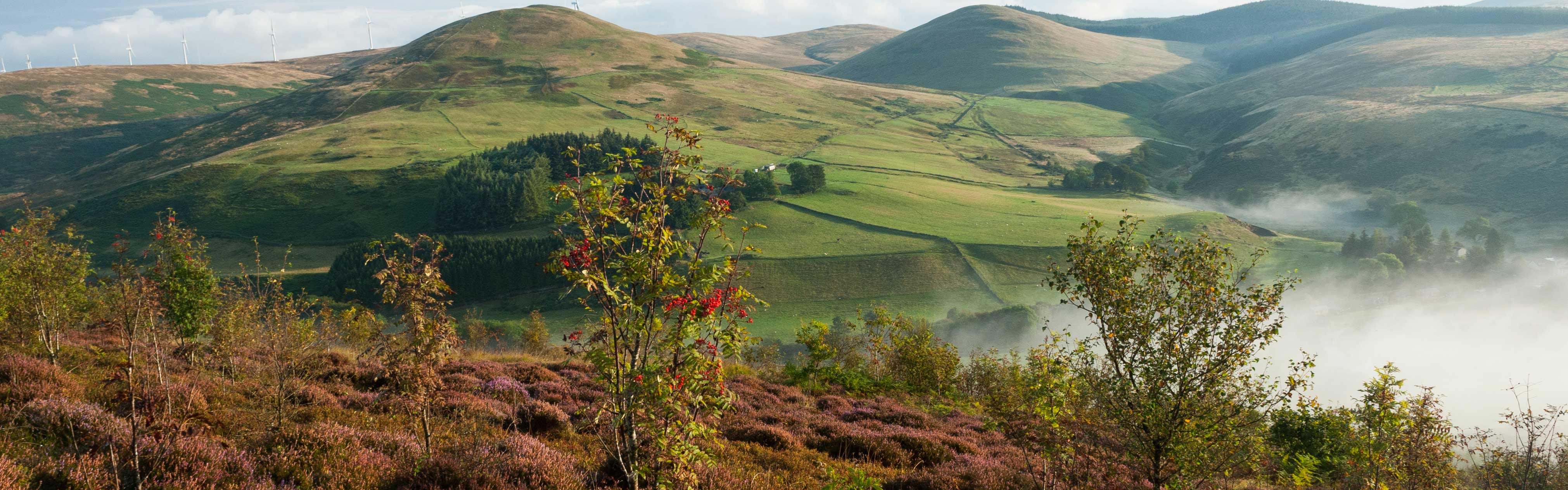
This particular stream, which becomes the River Sig, runs past Bugtor cottages and is typical of these moorland streams, deep set in ferns and bright flowers among the rocks as they chatter busily onwards, and it was here that Syd Wills, now living at St Budeaux, spent many happy hours of his childhood, and where he told me, ‘It was an unwritten law to let the foxes drink before you collected the duy’s water supply from the brook.’ He went on to tell me of the two Indies who once ran Bagtor House and the Barton as guesthouse nnd farm, their names Miss Blankiron and Miss Cross. Memories of them too came from Miss Catherine Haines, now in lu>r 80s and living at Bridford. She was a groom at Bagtor House in the 1920s. And here once again the tragedy of fire touched the Lemon’s tributary, the Sig. Early one morning she got up at five to go cubbing and saw clouds of smoke coming from the neighbouring liirm of Westabrook, an old thatched house standing near the banks of the river. She rushed down to wake up the Retallick family, who lived there, and to help the oldest member of the family from his bed and into the barn for safety. Eventually the fire engine arrived, ‘B ut,’ she said, thore was some problem over getting the pump started to take water I rom the stream, and I had to chase off to another farm for fuel. Meanwhile Mr Retallick was concerned about his watch which, as was his habit, he had tied to the bedpost for the night. It was resn ii‘(l — only to be stolen from him later. His son, Mr H. Retallick, now farms Bagtor Barton and he told me that recently when they were doing some repairs at Bagtor cottages they took down a partition and uncovered a small cubby hole like the ones from which lickots are sold at railway stations. ‘My guess is that is where they paid the men who worked in Newtake and Crownley M ines,’ he said and there are also the remains of a blacksmith’s shop and blowing house on the common.’ lie too remembered the two ladies from the Big House. ‘Proper 7


which have occurred on its banks. Here, at its beginnings, controversy once raged, for water used to be taken from it to feed the leat or pot water, the sole supply for Ilsington village, and Dick Wills, parish historian of Narracombe, whose family have farmed there for fourteen generations, told me there were many accusations from the thirteenth century onwards that too much water was taken, thus depriving the manor mill, Bagtor, of its supply, whilst the leat was feeding the mills of Ilsington, Liverton and Pool. ‘It seem s,’ he said ‘that there was a trough at the source and from a hole in this the water ran through the fields to Ilsington. The villagers used to go and make the hole bigger so more water ran their way. This caused a certain amount of ill feeling! ’ But for a moment we come back to the present century. On the night of 6 March 1970, when the Bovey police and their 250 guests were enjoying their twenty-first annual ball, soon after midnight everyone was asked to file out of the ballroom into the courtyard, and as they went they saw smoke pouring from the air vents, and outside flames were leaping from the roof of the hotel. The police tackled the fire with extinguishers until ten appliances arrived with sixty firemen, but all they could do was to stop the blaze Irom entirely destroying the hotel. A large section of the upper floor was wiped out and extensive damage caused to the ground floor. It was thought that the fire had started as the result of faulty wiring, but fortunately at least there were no casualties, four children who had been asleep upstairs being carried to safety. The following morning the police had to open up a special depot for people to pick up their coats at the police station in Newton Abbot, among them a silver mink. Much to everyone’s relief the draw money and prizes had also been saved! It was the biggest hotel fire in the area for years, and now it is known as the Hotel with no Guests, for it has remained an empty shell ever since. All you can hear as you stand looking over the gate is the whistling of the wind through the glassless windows. The owners did want to rebuild it on a bigger scale, but the plan was turned down by the Dartmoor National Park Comm ittee. At the entrance is a board which states CLOSED UNTIL FURTHER NOTICE. Could it perhaps be forever? Let us look now at something beautiful instead, for it is only fair to visit the Lemon’s main tributary while we are on this part of the moor — the River Sig which rises in Bagtor Mire under Rippon